
Trace Wake County Streets
A Wake County street search works best as an address-to-parcel trail. The assessor can connect a current street address to the Real Estate ID, or REID, and parcel identification number, or PIN. iMAPS then supplies the parcel boundary and layers that place it within a ZIP area, jurisdiction, subdivision, and street network. The Register of Deeds index can add dated instruments. For an older address, a printed street section and a map can test whether the number still refers to the same place. None of those sources alone identifies every person at an address.
- Enter the street number and name in Wake County Real Estate Search. Save the displayed situs address, REID, PIN, owner name, mailing line, and access date.
- Open the parcel in Raleigh/Wake iMAPS. Turn on Streets, Addresses, ZIP Codes, Corporate Limits, Planning Jurisdictions, Subdivisions, and municipal zoning before interpreting the address.
- Use the owner name, a prior reference, or book and page to search the Register of Deeds index. Read the dated instrument image before treating a name as part of an address history.
- For a historical question, compare the alphabetic and street sections of the nearest available directory editions. Record the publisher, year, page, exact printed spelling, and neighboring entries.
- Test a changed number or road name with a deed, plat, Sanborn sheet, or annexation material. Keep the year beside every crosswalk.
That sequence separates current parcel data from older address evidence. A street-by-street result is stronger when the number, parcel context, and date agree.
Wake County Assessor Street Rules
The assessor’s Location Address route asks for Street Number and Street Name. Street Name is required, while the number depends on the route. Wake County specifically instructs searchers to omit the street type, such as rd or dr. A partial or ambiguous name can return a refinement list, so try a full and abbreviated spelling before deciding an address is absent. The same service also offers owner, REID, and PIN routes, which are useful when a street search is uncertain.
| Wake search field | How it behaves | Useful street-directory note |
|---|---|---|
| Street Number / Street Name | Text fields; Street Name is required | Leave off the street type and test a partial name if needed. |
| Owner Name | Last name, optional first and middle, plus business-owner route | Use only after the parcel result provides a dated owner clue. |
| Real Estate ID | Text criterion | REID is a stable bridge from an address search to tax detail. |
| PIN Map/Scale/Block/Lot | Map fields | Scale is not part of Wake’s ten-digit PIN. |
Capture the situs address, owner line, mailing city and ZIP, subdivision, legal-description context, acreage, property class, and the identifiers shown. A situs address is the property’s physical location. A mailing address is where the tax record sends correspondence. They can differ. The assessor says its information can change as public records are filed and is provided without warranty, so a tax-card result is not a guarantee of current physical presence or legal title.
Note: If the address route fails, retry without the street type, then use a partial name or the REID/PIN from a related parcel result.
Wake County iMAPS Street Layers
iMAPS is the Wake County street directory’s map check, not a single-field lookup form. Its search and Identify tools work with property boundaries, lot dimensions, streets, addresses, deeds, permits, ZIP Codes, subdivisions, corporate limits, planning jurisdictions, precincts, districts, zoning, flood information, soils, parks, easements, and service layers. Layer dates vary. Record the layer name and the access date when a boundary matters. Use Corporate Limits for municipal status and the ZIP layer for postal geography.
The Raleigh/Wake iMAPS parcel viewer shows the practical map-led route from an address to a parcel and related tax or deed links.
Use the visible parcel outline as geographic context, then open each record separately. A map click can identify a parcel, but it does not establish a household relationship or a current resident.
Wake County Street Record Trail
Several Wake County sources can be keyed to an address, but their roles differ. The property roll supplies an assessment view. iMAPS supplies spatial layers. Recorded instruments document a filing at a stated time. Permits describe property activity. Voter information is time-sensitive and does not prove physical residence or identity. Pair the record type with the question instead of treating a search result as a complete street roster.
| Address-keyed source | Wake keeper | What it can show | Access route |
|---|---|---|---|
| Real Estate Search | Wake County assessor | Current parcel identifiers, owner and mailing fields, situs address | Free online search |
| iMAPS | Raleigh/Wake GIS | Parcel lines, street, ZIP, jurisdiction, subdivisions, deeds and permits layers | Free online viewer |
| Recorded instruments | Wake Register of Deeds | Dated deed, plat, easement, map, release, and related index entries | Online index and image, with mail or counter copy route |
| Permit records | Wake or relevant municipal custodian | Parcel activity, address, subdivision, dates, and record role | Legacy search, current portal, or a focused records request |
| Printed directories | Wake Public Libraries and DigitalNC | Edition-specific address listings and street sections | Library reference volumes or digitized scans |
North Carolina’s Public Records Act, N.C.G.S. Chapter 132, generally provides inspection and copying of existing public records, subject to exceptions. A request should name the custodian, address or identifier, date range, record type, and desired format. It does not require an office to create a custom street compilation.
Wake County Deeds By Street
The Wake Register of Deeds CRPI standard search has Doc Type, Search Type, Grantor, Grantee, recorded-date, Book, and Page fields. Search Type offers Standard and Sounds Like; grantor or grantee names need at least three characters, Book needs four, and dates use mm/dd/yyyy. Start with the parcel’s current REID/PIN and the owner name found on the tax card, then narrow by date or document type. CRPI is an index and finding aid, not the official underlying record. Search spelling variants, inspect the image, and preserve its book/page or document identifier.
The old CRPI application covers July 1785 through April 17, 2025 under the transition notice. The new Land Records application launched April 21, 2025 for the current route. Label the application used in research notes. Map books can be searched with BM plus a four-digit year; condominium maps use CM plus a four-digit year. Those codes can recover a plat lead when a name search is too narrow.
- Parcel
- A defined piece of land represented by an assessor identifier and map boundary.
- Situs address
- The physical location assigned to a parcel, distinct from an owner’s mailing line.
- Plat
- A recorded map that can show lots, boundaries, and subdivision context.
- Book and page
- An index reference that leads to a recorded instrument or map image.
For a certified recorded-document copy, the Register’s form gives a mail route and lists the document details needed to search. Confirm current charges and availability before ordering; an online image may already answer a limited address-history question.
Wake County Permit Dates
Permit results need a date boundary. The Wake legacy permit database is for records before July 1, 2018. Its fields include Applicant Name, Permit Number, Owner, Address, and PIN. A historic permit can help place a property change on a timeline, but its applicant, owner, or contact field is a record role, not proof of who lived there. The detail should stay tied to its permit number and dates.
The captured legacy interface is an example of the older address route.
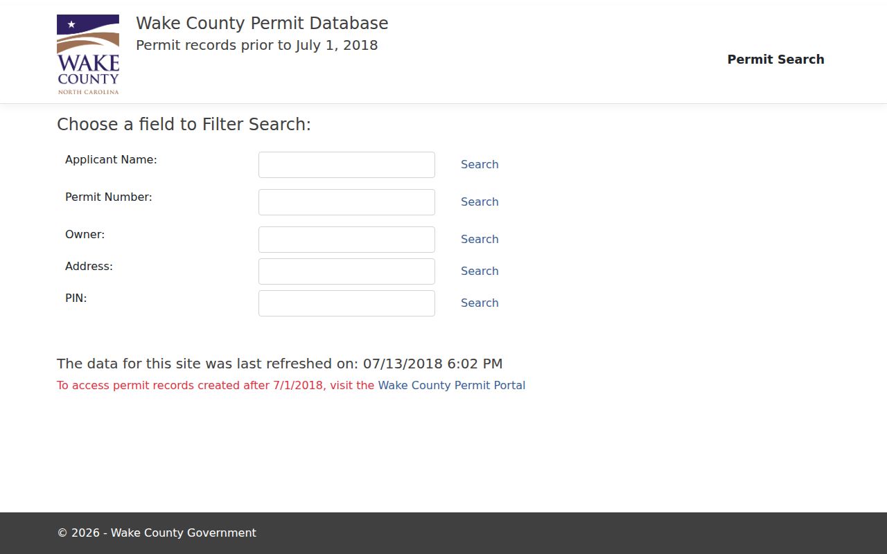
For Raleigh properties, the current Development Records route covers permit, inspection, certificate, zoning, and code-enforcement material. It describes an archive for 2010 through 2026 and current portal searching for post-January 1, 2025 ASR, recorded-map, plat, and subdivision cases. Keep the legacy and current routes separate. If a needed existing record is not online, use the relevant custodian’s focused public-record request channel.
Note: A permit date helps describe property activity, while an old permit’s listed roles remain limited to that record.
Raleigh Street Directory Entries
Historical street directory evidence is edition-specific. Read the title page and abbreviation key, then search both the alphabetic and street sections. Capture the publisher, edition year, page, exact spelling, address, printed household notation, telephone or other printed notation, and adjacent entries that clarify the block. Check the nearest prior and later editions. A changed listing is a clue to investigate with a deed or plat, not a complete account of an address.
Wake Public Libraries hold Raleigh City Directory volumes as noncirculating reference material at Olivia Raney Local History. The catalog shows intermittent early runs, extensive later coverage, and edition gaps. DigitalNC provides searchable or browsable scans by city, county, and year. For the broader historical shelf and its collection gaps, use the Wake County city directory collections after the street address has been established.
Raleigh Street Names Change
Do not force an old street label into a modern spelling without evidence. Raleigh coordinates new street names with Wake County. The City’s new-street rules describe constraints on length, words, punctuation, duplication, and names honoring people, with an approximately ten-business-day review and no fee. The street-change process requires a petition, recorded plat, owner list, parcel-number map, fee, and review.
The observed Raleigh example changes Church at North Hills to Bridge at North Hills effective December 31, 2026. That date is useful because it shows why a street-directory crosswalk needs an effective date. Research did not establish one citywide street-renumbering year. Bridge an earlier address with the printed directory, deed, plat, Sanborn map, and annexation context instead of asserting a universal conversion.
Wake County Postal Place Checks
An address line can carry a postal place name, neighborhood label, or municipal jurisdiction that does not mean the same thing. Use iMAPS ZIP Codes for postal geography and Corporate Limits for municipal status. A Raleigh postal label can sit outside Raleigh corporate limits, and a parcel can have a different planning jurisdiction. Write the result precisely as mailing address, postal ZIP, or municipal jurisdiction.
For a street-and-ZIP question, first locate the parcel in the assessor, then compare iMAPS ZIP and Corporate Limits layers. The Wake County ZIP code directory keeps the ZIP-specific reference map and Census boundary cautions together.
Note: Postal labels guide address handling, while the iMAPS Corporate Limits layer is the Wake County check for municipal status.
Wake County Street History Evidence
Sanborn sheets test a building’s footprint, land use, materials, and street context. They do not list every resident. The Library of Congress holds Raleigh sheets from 1884, 1888, 1896, 1903, 1909, 1914, and later editions through December 1950. Match the street number, block, parcel, and date before connecting a directory line to a mapped structure.
A careful Wake County address trail can compare a 1900 directory listing, a 1914 Sanborn sheet, a 1925 or 1933 DigitalNC scan, a deed or plat, a dated permit, and the current REID. That is a sequence of evidence, not an assertion of uninterrupted occupancy. Annexation, subdivision, widening, or renumbering can change what the same number represents.
Wake County Street Directory Limits
Owner of record, permit applicant, directory entry, and voter result each describe a different role and time. The assessor’s owner field does not establish occupancy. A voter result reports registration status at search time and is not identity proof. A current tax card cannot supply a full historical address trail. DMV personal information is restricted, and confidential voter, vital, court, and protected-address material must remain protected.
Use address records lawfully. North Carolina’s anti-stalking law covers repeated conduct without legal purpose that causes or intends fear or distress. Keep research limited, do not republish unnecessary address detail, and never use records to threaten, intimidate, stalk, or harass a person.
Use the smallest set of fields needed for family history, property research, civic questions, or a dated records request. A substitute address from the North Carolina Address Confidentiality Program is never a reason to seek a protected location.